
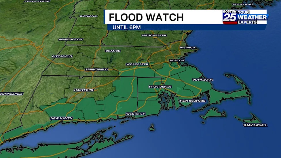
A significant flood watch has been placed into effect across major portions of Massachusetts and southern New England as meteorologists warn of incoming heavy downpours capable of triggering localized flash flooding. The weather system, carrying clusters of intense precipitation, poses serious drainage and safety concerns across several key regions through the afternoon hours.
In response to the hazardous conditions, forecasters with the Boston 25 Weather Team have instituted a Severe Weather Alert across the viewing area. The active flood advisory is slated to remain in place through 6:00 p.m. on Sunday, urging residents in threatened zones to remain vigilant and avoid unnecessary travel through flood-prone lowlands.
The geographical scope of the alert encompasses eight separate counties across the Commonwealth. Official advisories confirm that Bristol, Plymouth, Barnstable, Dukes, Nantucket, Worcester, Norfolk, and Suffolk counties are all included under the watch, covering major inland population hubs as well as coastal and island communities.
According to Boston 25 meteorologist A.J. Mastrangelo, the storm system is driving a cluster of heavy rainfall across the state, sliding progressively toward southeastern Massachusetts during the late morning. Mastrangelo noted that the designated flood watches are set to persist through 6:00 p.m., specifically impacting communities situated along and south of the Massachusetts Turnpike.
Atmospheric conditions across southern New England are primed to deliver widespread showers accompanied by occasional embedded thunderstorms. Forecasters emphasize that the primary danger stems from narrow, highly concentrated bands of torrential rain that could develop within the broader precipitation field.
Overall precipitation estimates indicate that most communities within the watch area should anticipate widespread rainfall accumulation ranging between 0.50 and 2.0 inches. However, forecasters caution that significantly higher localized totals remain a serious threat wherever the storm's most intense bands stall or repeatedly track over the same locations.
Under these narrow, high-intensity corridors, localized downpours could deposit anywhere from 2 to 4 inches of water within an extremely compressed three-hour timeframe. Such rapid rainfall rates frequently overwhelm standard drainage infrastructure, transforming roadways and low-lying sectors into hazardous waterways in a short period.
Forecasters with the National Weather Service have highlighted the delicate nature of tracking these intense weather bands while warning the public about their unpredictable nature. The agency stated that while uncertainty persists regarding the precise placement and occurrence of the narrow heavy rain ribbons, localized flash flooding remains a distinct possibility.
The weather service issued a specific caution concerning urban environments, noting that the threat of rapid inundation increases dramatically if the torrential bands develop over vulnerable city corridors. Densely paved municipalities, such as those found in Suffolk and Norfolk counties, face heightened risks due to extensive impervious surfaces that prevent water absorption.
Coastal and island regions, including Barnstable County on Cape Cod as well as Dukes and Nantucket counties, must contend with the combined impact of intense rainfall and saturated coastal terrain. As the cluster moves through southeast Massachusetts, these maritime areas face sustained moisture through the late afternoon.
Meanwhile, inland areas along the Mass Pike and across Worcester County are keeping a close watch on shifting storm boundaries. With rainfall potentially escalating around midday, local officials and transportation personnel are monitoring roadway conditions across central Massachusetts to respond to sudden pooling or runoff.
To assist the public throughout the severe weather event, state officials recommend utilizing digital emergency resources to monitor safety hazards. Residents are encouraged to consult the Massachusetts Emergency Management Agency real-time power outage viewer, which provides updated statewide data on regional electrical service interruptions alongside estimated restoration schedules provided by utility companies.
In addition to outage mapping, emergency planners emphasize the importance of utilizing the live weather radar and forecasting tools supported by state emergency management to track the movement of heavy precipitation clusters in real time. Accessing up-to-the-minute radar feeds allows residents to make timely decisions before localized flooding escalates.
A network of support channels remains available to assist residents during the adverse weather window, including community assistance through Mass211 and federal coordination capabilities backed by the Federal Emergency Management Agency. Public safety partners emphasize early preparation and continued awareness during active watches.
Forecast operations across the region continue to be monitored closely by National Weather Service field offices in Boston and Albany, New York, which provide ongoing updates as atmospheric conditions evolve. Residents throughout the affected Massachusetts counties are advised to monitor official channels and exercise caution until the flood watch expires Sunday evening.






(0)